Prediction and Mechanism Elucidation of Heavy Rainfall
Heavy Rainfall Mechanisms & Climate Change Impact AssessmentIn recent years, severe heavy rainfall disasters have occurred frequently across Japan. Particularly in the Kyushu region, devastating heavy rains have followed one another, such as the Northern Kyushu Heavy Rainfall in 2017 and the Heavy Rain Event of July 2020 (Kuma River system). Furthermore, localized torrential rains causing fluvial and inland flooding are now occurring almost annually. Our laboratory aims to elucidate the generation mechanisms of these heavy rainfall phenomena by using a wide variety of observational data—including satellite data, weather radar, and ground observation stations—combined with numerical simulations using regional weather models. Additionally, as research anticipating climate change countermeasures, we conduct local-level heavy rainfall prediction via "dynamical downscaling" of future climate projection data, and estimate "Probable Maximum Precipitation (PMP)" for various basins using regional atmospheric models. Through these research results, we aim to contribute to disaster prevention and mitigation against intensifying heavy rainfall disasters and to the construction of a sustainable regional society.
1. Analysis of Heavy Rainfall Mechanisms Using Observational Data
High Spatiotemporal Resolution Radar (XRAIN)
Currently, the Ministry of Land, Infrastructure, Transport and Tourism (MLIT) maintains a network of X-band MP radars in Japan. By combining this with C-band radar, it is possible to grasp the precipitation distribution across Japan with the high detail of 1-minute intervals and approximately 250m resolution. A major feature of X-band MP radar is its ability to observe 3-dimensional precipitation distribution in 5 minutes. We utilize this data to analyze the mechanisms of heavy rainfall, focusing on northern Kyushu.
Meteorological Satellite Himawari
The meteorological satellite Himawari is familiar from news weather forecasts. While visible and infrared images are commonly seen, these are only a part of what Himawari observes. It carries a high-performance radiometer (AHI) with 16 wavelength bands. We are proceeding with analyses related to heavy rainfall using Himawari data.
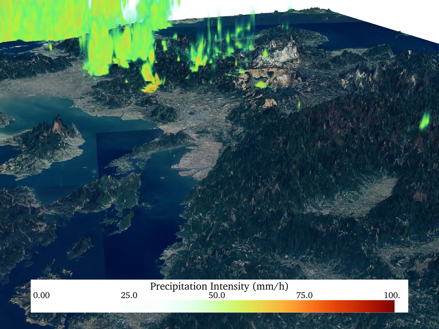
3D analysis using radar data
(Using XRAIN and GSI aerial photos)
2. Analysis of Heavy Rainfall Using Regional Atmospheric Models
Reproduction Simulation of Heavy Rainfall
First, we perform reproduction calculations of heavy rainfall through high-resolution 3D atmospheric simulations using regional atmospheric models. Depending on the heavy rainfall event, we use a resolution of several hundred meters to 1 km when analyzing heavy rain in Kyushu. We adjust the atmospheric model to reproduce the actual precipitation distribution.
Analysis of Heavy Rainfall Mechanisms
Since regional atmospheric models simulate 3D physical processes, the output data covers all atmospheric variables such as water vapor amount and air temperature. In our laboratory, we achieve precise 3D analysis reflecting detailed topography by calculating at an extremely high resolution of several hundred meters to 1 km. Making full use of this simulation data, we are elucidating the generation mechanisms of heavy rainfall. By revealing the true nature of heavy rainfall, we aim to contribute to social disaster prevention and mitigation through improved prediction accuracy.
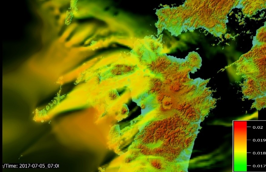
Analysis of the 2017 heavy rainfall (Ishida et al., 2017)
3. Future Prediction via High-Resolution Simulation
Dynamical Downscaling of Future Climate Projection Data
Future climate predictions are performed using Global Climate Models (GCMs). Due to limited computational resources, GCMs often have horizontal resolutions of 100 km or more, which is too coarse for local or basin-level analysis. Additionally, they cannot adequately represent atmospheric conditions during heavy rainfall in Japan within the simulation. Therefore, we perform high-resolution conversion (dynamical downscaling) using regional atmospheric models.
Nationwide Simulation at 2km Grid
We are currently proceeding with dynamical downscaling to cover all Class A river basins across Japan. We divide the computational domain of the regional atmospheric model into multiple parts and adjust the model for the basins within each domain. Upon doing so, we proceed with the dynamical downscaling of future climate projection data. By conducting this at a high resolution of 2 km, future prediction reflecting Japan's complex topography becomes possible.
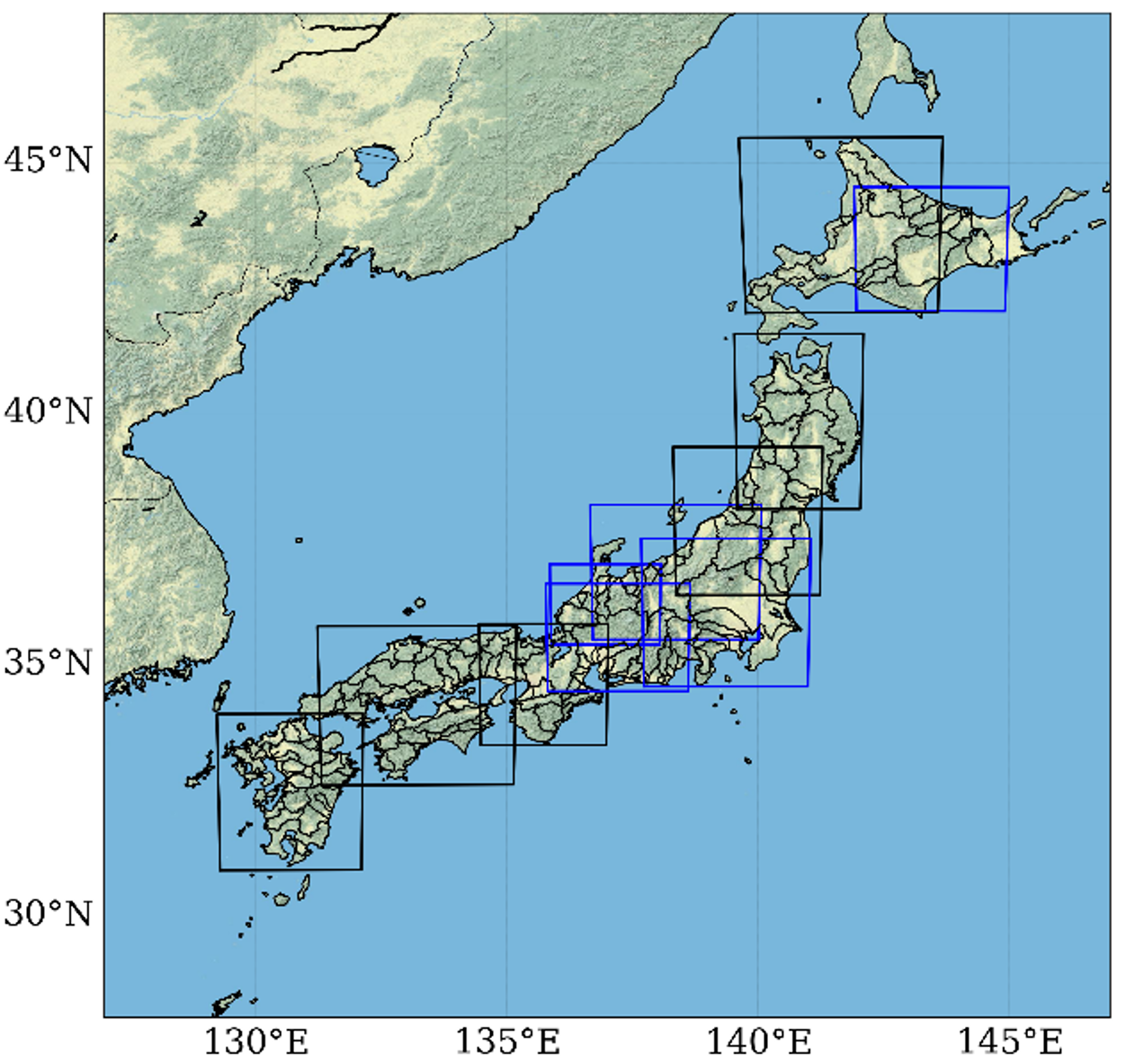
Computational domains covering all Class A river basins
4. Estimation of Physical Upper Limits of Precipitation
Estimation of Probable Maximum Precipitation (PMP)
Knowing how much rain can physically fall in a region or basin is crucial information for implementing flood control measures, including the design of hydraulic structures. Conventionally, statistical methods have been used to estimate this "Probable Maximum Precipitation (PMP)." However, statistical methods have issues with not being able to appropriately include the effects of topography or global warming. Therefore, we are developing estimation methods for Probable Maximum Precipitation using regional atmospheric models.
Case Study in California, USA
This method was developed targeting watersheds in California on the US West Coast. The research was highly evaluated in the United States and received the J. James R. Croes Medal, 2016 from the American Society of Civil Engineers (ASCE).
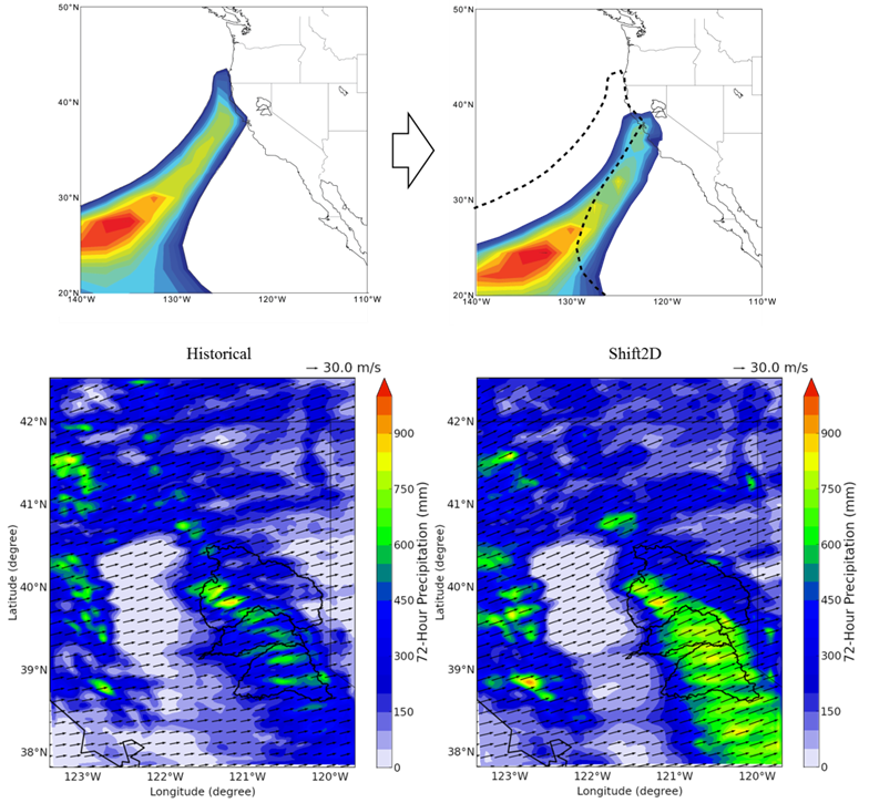
Estimation of PMP based on physical processes
(Ishida et al., 2017)